
Transforming Cities with the CIM Methodology
2 June 2021 by Eduardo García Martín
"Cloud computing, big data, social media, mobility — these are the technologies that will drive digital transformation investment to grow by around 25% in the coming year."
"The 21st century will be the century of cities. Global urbanization — with more than half the world's population already living in cities — and the digital revolution are converging to create a hyperconnected, collaborative society. At that intersection, the Smart City concept takes on a special significance. Europe, already well positioned in urban development, now has an opportunity to use cities as a platform for the digital transformation of its economy and society. Latin America, meanwhile, can harness digital transformation to tackle its most pressing economic and social challenges." — Telefónica
The core idea behind CIM (City Information Modelling) is an intelligent city model — analogous to what BIM does for buildings and infrastructure — that holds detailed information about every urban entity and the relationships between them. Planners and designers can use a CIM model to plan cities more efficiently and effectively, simulating everything from traffic flows and energy consumption to waste management, street cleaning, and natural disaster impact. There is, in effect, a one-to-one relationship between CIM and what we now call Smart Cities.
People are moving to cities faster than at any other point in history. By 2040, architects, planners, engineers, and construction firms around the world will need to design and build 10,000 new smart cities and their buildings — and CIM is the methodology that will make that possible.
Think of CIM as the real-world successor to SimCity or today's Cities: Skylines: impressive simulations at the game-software level, but applied to actual cities. Expert definitions generally describe a CIM as a fully integrated, semantically enabled "super-BIM" 3D city model that connects users to any data source or contextual analysis tool — static or dynamic, spatial or non-spatial — spanning buildings, roads, public spaces (open data), streetlights (sensors / IoT), and people on the street (social networks) [1].
A platform moving in exactly this direction is Cityzenith's Smart World CIM [6] — driven by the team behind Google Earth — which is already used by architecture, engineering, and planning professionals worldwide.
Given this landscape, understanding a city's level of digital maturity is increasingly critical: both for deploying new solutions and for calibrating the technology strategies of the organizations operating within it.
Smart City projects are the primary vehicle for technological innovation in cities today. Yet too often they arrive as isolated digital initiatives — siloed innovations with weak links to the Smart City strategy's action plan before, during, and after implementation.
When that happens, the indicators being measured don't feed the dashboards that actually support decision-making. The result is poorly developed Smart platforms that generate data nobody acts on.
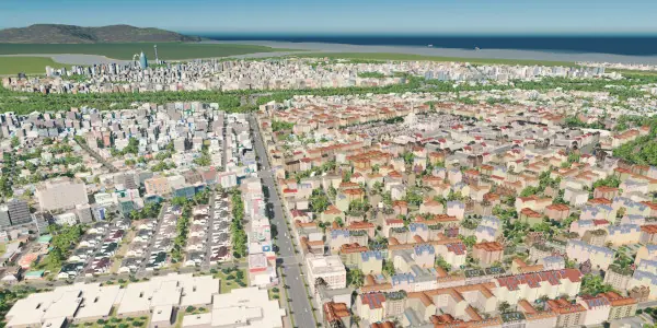 A CIM model applied to urban planning.
A Concrete Implementation
Sant Cugat del Vallès, Spain, offers a compelling real-world example [4]. The city commissioned a full urban-services management system based on a CIM model, covering the entire municipality and establishing clear order among people, processes, and tools — whether the structures are new or existing.
The system, adapted specifically for urban services, consolidates existing and future data across every service domain — waste collection and street cleaning, street lighting, sewerage, public roads, parks and gardens, mobility, and utility networks (telecommunications, telephony, electricity, drinking water, and gas) — into a single unified database. Its core functions include:
- Building a 3D view of the municipality, with all urban elements on a single GIS database.
- Inventorying every component of every urban service across all concessions and departments, at a minimum LOD 300 detail level.
- Providing an open channel through which citizens can access information of public interest.
- Accelerating the opening and closing of incident reports.
- Flagging critical-point indicators across each service, covering completed works, active projects, and planned future works.
- Forecasting maintenance investment and energy consumption.
Beyond the well-known social, economic, environmental, and cultural challenges cities face, there is a more fundamental driver at work: the convergence of global megatrends with a connected, collaborative society. That convergence is the real engine of urban change.
The boundary between the digital and physical worlds keeps blurring, opening new possibilities for digital business. The digital world is becoming an increasingly detailed reflection of the physical one — and will eventually appear as part of it, creating fertile ground for new business models and digitally enabled ecosystems.
Under these megatrends — some of which are here to stay and will reshape how things get done — cities emerge as the physical space where these changes will unfold. That puts cities under growing pressure to become engines of territorial innovation.
Too often, Smart City innovation still arrives as a hermetically sealed silo: a digital initiative with little connection to the broader Smart City strategy's action plan, before, during, or after deployment.
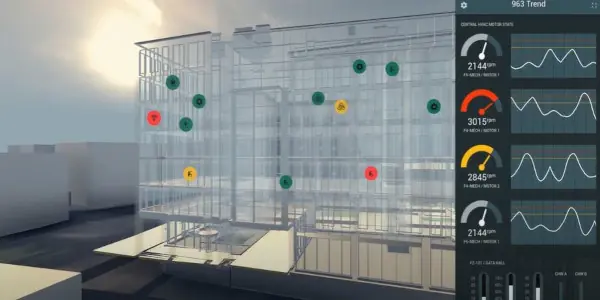 Integrated urban infrastructure within a CIM model.
By enabling open data exchange and fostering digital trust, cities can build genuine digital communities. Connecting cities horizontally makes it possible to compare and share information across jurisdictions — creating networks that accelerate digital transformation, support better decision-making, and spread proven practices that raise the bar for everyone.
CIM, BIM, and the ISO 37120 Standard
CIM's value is inseparable from BIM. A CIM model lets planners simulate traffic, energy use, waste management, street cleaning, and natural disaster scenarios across a whole city, while BIM handles the building-level detail. The two methodologies are mutually reinforcing [2][3][5].
This is directly relevant to ISO 37120, the international standard for city performance indicators, which incorporates CIM and BIM in its framework for sustainable urban development.
A water supply network is a useful illustration. Assessing drinking water access, supply interruptions, and distribution losses — and understanding their impact on quality of life and local development — requires data from two levels. BIM models of the buildings yield five indicators (access and consumption). CIM models of the supply network infrastructure yield two more (interruptions and losses). Neither methodology alone covers the full picture.
Conclusions
- City Information Modelling (CIM) is essential for implementing sustainable concepts at the city scale.
- BIM and CIM together enable real-time observation of urban development.
- Combined, they can automate 53 of the 100 indicators specified in the ISO 37120 standard.
- Sustainable development — whether for individual buildings or entire cities — is not achievable without BIM and CIM methodologies.
References
- The Importance of City Information Modeling (CIM) — Semantic Scholar
- BIM, CIM: Connected Cities and Smart Buildings — Editeca
- From BIM to CIM — Architect Magazine
- IDP Awarded the CIM Project for Sant Cugat del Vallès — IDP
- Next in BIM: City Information Modeling (CIM) — Constructivo
- The Cityzenith Difference — Cityzenith
- Digital Transformation: Trends and Indicators for the City Ahead — Política Comunicada
Eduardo García, Engineer — egarcia@innotica.net — LinkedIn